Introduction to Mount Rinjani: Indonesia’s Iconic Volcano
Perched majestically on the Indonesian island of Lombok, Mt. Rinjani is not just a mountain; it is an enduring symbol of natural beauty, geological significance, and cultural heritage. As the second highest volcano in Indonesia, standing at an impressive 3,726 meters (12,224 feet), Rinjani commands both respect and admiration from locals and adventurous travelers alike. Its towering presence dominates the landscape of West Nusa Tenggara, drawing thousands of trekkers, scientists, and nature enthusiasts each year seeking to experience its raw power and breathtaking vistas.
Geographical Overview of Mount Rinjani
Mount Rinjani is situated within the Rinjani Volcanic Complex on Lombok Island, in the province of West Nusa Tenggara. It forms part of the UNESCO-recognized Rinjani Nature Reserve and is encompassed within the Gunung Rinjani National Park, which spans over 41,330 hectares. The volcano is characterized by its active status, with eruptions recorded as recently as December 2015, making it one of Indonesia’s most active and intriguing volcanoes.
The mountain’s unique geological structure includes a massive caldera known as Segara Anak, which measures approximately 8 by 11 kilometers. Inside this caldera lies a crater lake of the same name—Segara Anak (Child of the Sea)—whose turquoise waters are fed by thermal springs, creating a striking contrast to the rugged volcanic landscape. The surrounding terrain features lush tropical forests, diverse ecosystems, and a variety of endemic flora and fauna, making it a vital ecological zone.
Historical Significance and Eruption History
Historically, Mount Rinjani’s eruptions have shaped not only the landscape but also the local culture and settlement patterns. The volcano’s activity dates back thousands of years, with significant eruptions recorded in recent history, notably in 2015, which led to temporary disruptions but also contributed to land fertility and ecological succession.
The 2015 eruption was notable for its ash plumes reaching up to 6 kilometers in altitude, causing air traffic disruptions and a temporary closure of trekking routes. Nonetheless, the volcano remains a significant subject of scientific study due to its active status and complex eruption cycle. Its eruptions have historically been veiled in local legends, often viewed as manifestations of divine forces—thus embedding a spiritual significance into local beliefs and cultural practices.
Conservation Status within Gunung Rinjani National Park
Designated as part of the UNESCO Biosphere Reserve and a national park, Mount Rinjani plays a critical role in Indonesia’s conservation efforts. The park aims to protect its diverse ecosystems, including rare flora and fauna such as the Flores hawk-eagle and the Rinjani scops owl. Preservation initiatives focus on sustainable tourism, ecological monitoring, and community engagement.
Community-based conservation programs have been integral in balancing ecological integrity with local livelihoods. Visitors are encouraged to adhere to eco-friendly guidelines, such as minimizing waste, avoiding disturbing flora and fauna, and respecting local customs. The park authority also collaborates with local communities to promote eco-tourism, ensuring that natural resources are preserved for future generations.
Climbing Mount Rinjani: Trail Types and Preparation
Popular Trekking Routes (Sembalun, Senaru, Torean)
Embarking on a trek to Mount Rinjani requires choosing the right route, as multiple trails lead to the summit, each offering unique challenges and scenic experiences. The three primary routes are Sembalun, Senaru, and Torean, with Sembalun and Senaru being the most popular among climbers.
- Sembalun Route: Starting from Sembalun Lawang, this trail is favored for its relatively gentle ascent and low-risk landscape. It passes through lush grasslands, volcanic craters, and panoramic viewpoints, making it ideal for hikers seeking a moderate challenge and incredible scenery.
- Senaru Route: Originating from the village of Senaru, this route is slightly more challenging due to its steeper terrain. It is renowned for its hauntingly beautiful waterfalls and dense rainforest, offering a more immersive jungle experience before reaching high-altitude terrain.
- Torean Route: Less frequented, Torean begins near the Torean village and provides a more adventurous trail, often combined with other routes for experienced trekkers seeking to explore the full landscape diversity.
Advanced routes and multi-day expeditions are also available, often incorporating acclimatization days to combat altitude sickness. Many trekkers choose guided packages that include permits, gear, and local guides to ensure safety and to enhance the experience with local insights.
Necessary Gear, Fitness Requirements, and Safety Tips
Climbing Mount Rinjani is a physically demanding adventure that requires proper preparation. Essential gear includes sturdy hiking boots, layered clothing for varying temperatures, rain gear, headlamps, trekking poles, gloves, and thermal wear. Because weather conditions can change rapidly, packing warm and windproof clothing is advisable even during dry season.
Fitness plays a crucial role; trekkers should have a good level of cardiovascular endurance and hiking experience. Preparing through regular aerobic exercises, strength training, and altitude acclimatization hikes can significantly improve performance.
Safety tips include staying hydrated, avoiding alcohol, scheduling ascent and descent during daylight, and listening to guides’ advice. It is also vital to be aware of altitude sickness signs—such as headaches, dizziness, and nausea—and to descend promptly if symptoms worsen.
Guides, Permits, and Booking Essentials for Trekkers
A certified mountain guide is mandatory for safety reasons, especially since Rinjani is an active volcano. Guides can be hired through local operators who also handle permits, equipment rentals, and logistics. Costs vary depending on the route and package but typically range from Rp. 350,000 to Rp. 500,000 per day for guides.
Permits are issued by the Rinjani National Park authority and are included in guided tour packages or can be purchased individually at the entrance points. It is advisable to book months in advance during peak seasons to secure permits and accommodations.
Highlighting the Attractions of Mount Rinjani
Segara Anak Lake and Hot Springs
One of the most captivating features of Mount Rinjani is the crater lake, Segara Anak. Its shimmering turquoise waters sit within the caldera and are surrounded by hot springs, which provide a soothing experience after trekking through volcanic terrain. Local legends often refer to Segara Anak as a sacred site, and many visitors partake in spiritual rituals here.
Rinjani Waterfalls and Surrounding Flora & Fauna
The journey to Rinjani also involves exploring its diverse ecosystems, including spectacular waterfalls such as Sendang Gila and Tiu Kelep near Senaru. These waterfalls cascade through lush tropical forests teeming with endemic species, offering excellent opportunities for photography and birdwatching. The flora includes rare orchids, medicinal plants, and towering trees, while the fauna encompasses various bird species, monkeys, and insects endemic to Lombok’s environment.
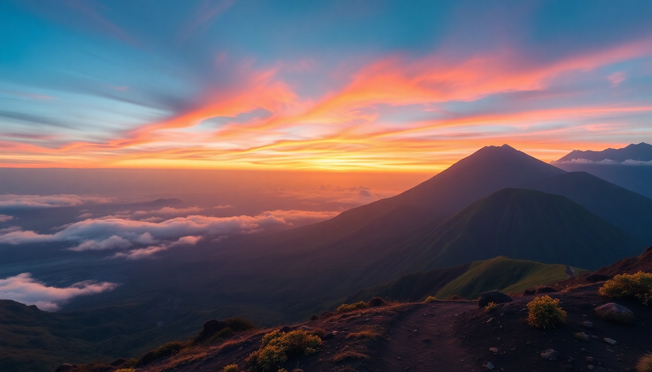
Scenic Viewpoints and Sunrise Spots for Photography
Numerous vantage points along the trekking routes and summit provide awe-inspiring views. The sunrise from the summit is arguably the most iconic moment, with panoramic vistas of the clouds, surrounding islands, and the endless sky—an experience that attracts amateur and professional photographers alike.
Best Time to Visit and Climbers’ Tips
Optimal Seasons and Weather Considerations
The ideal time to climb Mount Rinjani is during the dry season, spanning from April to November, when weather conditions are most stable. Between June and September, the weather is typically warmer and clearer, maximizing visibility and safety. The rainy season (December to March) brings heavy rainfall, muddy trails, and increased volcano activity, which can complicate ascent and descent.
Preventing Altitude Sickness and Acclimatization Advice
To minimize altitude sickness risk, gradual ascent is crucial. Many guides recommend spending a day acclimatizing at intermediate elevations and maintaining hydration levels. Recognizing early warning signs allows for prompt descent, which is the most effective remedy. Acclimatization also involves proper nutrition, avoiding overexertion, and dressing in layers to regulate body temperature effectively.
Post-Ascend Activities and Exploring Lombok’s Culture
After conquering Rinjani, visitors can enjoy cultural tours in Lombok, experiencing traditional Sasak crafts, local markets, and indigenous music. Relaxing on the island’s pristine beaches or exploring nearby islands such as Gili Trawangan adds a complete backpacking experience. Engaging with local communities also enriches understanding of Lombok’s cultural heritage and sustainable tourism practices.
Mount Rinjani: Trekking Challenges and Emergency Protocols
Physical Challenges and How to Prepare
Climbing Mount Rinjani involves traversing rugged volcanic terrain, high-altitude environments, and variable weather conditions. Common challenges include fatigue, dehydration, altitude sickness, and unpredictable weather. Preparation involves cardiovascular conditioning, strength training, hiking endurance, and mental resilience training. Conducting acclimatization hikes and packing appropriate gear are essential strategies for success.
Safety Measures During the Climb
Safety protocols include sticking closely to designated paths, following guides’ instructions, and maintaining communication devices charged. Trekkers should carry a first aid kit, extra food, and warm clothing. Regularly checking weather updates and the volcano’s activity status is vital, especially during active periods.
Handling Emergencies and Lost-in-Forest Protocols
In case of emergencies, climbers should alert their guides immediately. Emergency protocols involve descending quickly if signs of distress appear, or seeking shelter if weather deteriorates. If lost, maintain calm, stay in place, and try to signal rescuers using whistles, reflective clothing, or signaling devices. Pre-arranged communication plans, such as GPS devices or emergency contact numbers, significantly improve rescue success rates.